CREB Track
71 km
distance
8h
Contour time
4.8
avg score
Unsealed
surface
Scenery
Queensland
The Daintree Rainforest is the oldest continuously surviving tropical rainforest on earth - over 135 million years old,...
Road quality
4.8 RQS
Every segment scored on 40+ data signals.
Accessibility
Fully sealed
Best in 4WD modified. Peak season: May-October.
7-day forecast
This is a winch track. Deep mud holes, severe ruts from previous vehicles, fallen trees blocking the track and water crossings that can exceed bonnet height after rain. A winch is not optional - you will use it. Minimum two vehicles travelling together. Not suitable for stock 4WDs regardless of driver skill.
Scored 4.8/10 by Contour's road quality algorithm across curviness, surface, elevation and traffic. Best suited for 4wd modified drivers.
The road
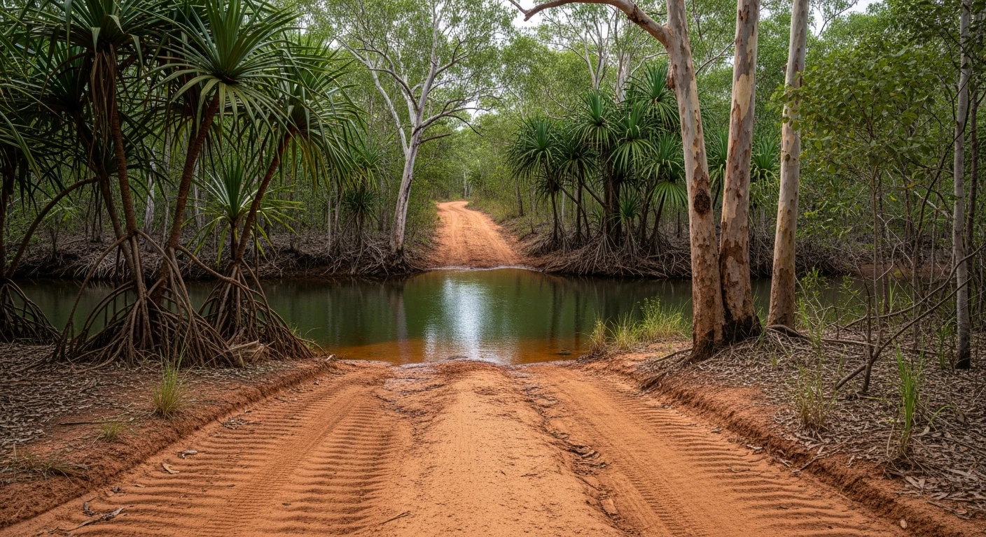
The CREB Track is the Daintree's hard option. Where the Bloomfield Track is famous and well-travelled, the CREB is infamous and mostly avoided. The 71-kilometre route links Daintree Village on the coast side to Wujal Wujal on the Bloomfield River, cutting through the heart of the Daintree Rainforest via a route that was originally a power line access track - CREB stands for Cairns Regional Electricity Board. The track climbs from near sea level to the McDowall Range at around 900 metres, traversing terrain that receives some of the highest rainfall in Australia. Even in the dry season the mud never fully dries in the deep ruts and shaded gullies. The track surface alternates between exposed root systems, deep clay mud, loose rock on the range sections and standing water in the lowland crossings. Fallen trees block the track regularly and a chainsaw is standard equipment for any CREB attempt. The water crossings in the lowland sections can be deep enough to submerge a standard bonnet line after upstream rain - a snorkel is essential, not precautionary. The track takes 6-10 hours depending on conditions, vehicle capability and how many times you need to winch. There is no phone coverage, no alternate exit for most of the route and no other traffic to rely on for help. This is a track where preparation determines outcome. Poorly equipped vehicles get stuck and stay stuck until someone with a winch comes along - which could be days. The reward is genuine primary tropical rainforest in a way that no other track in Australia delivers. The canopy closes completely overhead for kilometres at a time. The birdlife is extraordinary. Cassowaries are resident. The sense of isolation is total.
The CREB Track is the Daintree's hard option.
Why this road
The region
The Daintree Rainforest is the oldest continuously surviving tropical rainforest on earth - over 135 million years old, predating the Amazon by roughly 125 million years. The section the CREB Track passes through is among the least visited and least modified parts of the forest. Daintree Village at the southern end is a small settlement on the Daintree River, accessible by cable ferry from the Captain Cook Highway. Wujal Wujal at the northern end is an Aboriginal community on the Bloomfield River with limited visitor services.

Before you go
Fuel at Daintree Village (limited) or Mossman (30 minutes south). No fuel on the track or at Wujal Wujal. Travel in convoy of minimum two vehicles - solo attempts are irresponsible on this track. Carry a winch, chainsaw, snatch strap, recovery boards, satellite communicator and enough water for 24 hours in case of a breakdown or bogging that takes overnight to resolve. The track is closed in the wet season and should not be attempted in the shoulder months (November, April) even if technically open. Check with Daintree locals for current conditions before committing. Allow a full day - 8 hours minimum. No mobile coverage for the entire route.
See a routing error?
Flag itWorth stopping for
Daintree River cruise
Crocodile spotting cruises depart from Daintree Village multiple times daily - a good way to decompress after the CREB.
Bloomfield Falls
A sacred waterfall near Wujal Wujal at the northern end of the track - check access with the local community before visiting.
Route
Start
Daintree Village
End
Wujal Wujal
Gallery

More roads like this