Bloomfield Track
100 km
distance
4h
Contour time
3.8
avg score
Unsealed
surface
Scenery
Queensland
The Daintree coast between Cape Tribulation and Cooktown is where two World Heritage areas meet - the Daintree...
Road quality
3.8 RQS
Every segment scored on 40+ data signals.
Accessibility
Fully sealed
Best in 4WD. Peak season: May-November.
7-day forecast
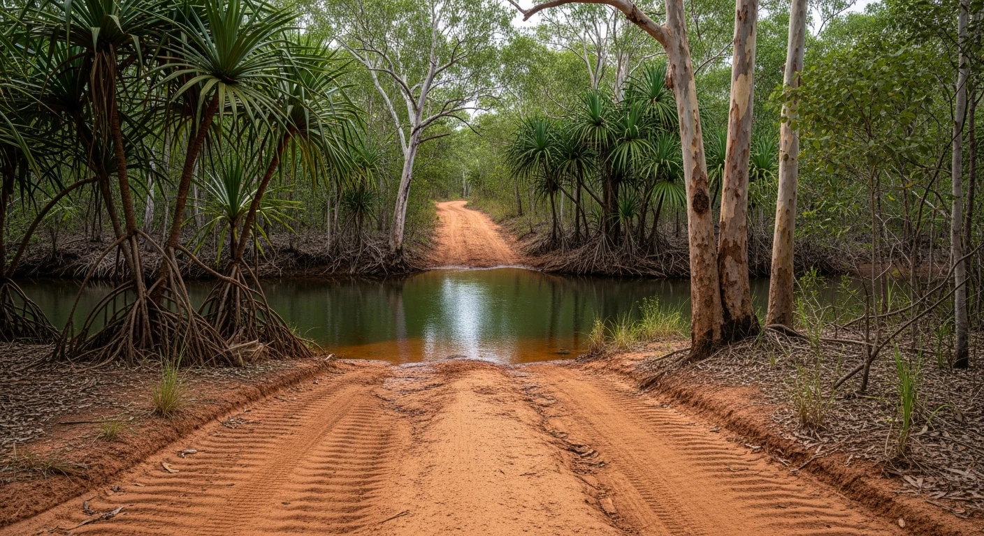
The core 30-kilometre 4WD section between Cape Tribulation and the Bloomfield River is genuine Grade 3. Donovan's Range and Cowie Range have gradients exceeding 33% on loose rocky surface. The rest of the 100km route is graded unsealed road suitable for any high clearance vehicle. The core section is the test.
Scored 3.8/10 by Contour's road quality algorithm across curviness, surface, elevation and traffic. Best suited for 4wd drivers.
The road
The Bloomfield Track is 100 kilometres of road connecting two of Far North Queensland's most distinctive towns - Cape Tribulation at the edge of the Daintree, and Cooktown at the mouth of the Endeavour River. The first 30 kilometres north of Cape Tribulation are the reason this track has a reputation. Donovan's Range and Cowie Range present steep, rocky gradients that exceed 33% in places on a surface of loose rock and exposed bedrock. In the wet season the rock becomes slick and the track becomes genuinely dangerous. Creek crossings through the lowland sections between the ranges can flood without warning after upstream rain. The road was controversially bulldozed through World Heritage rainforest in 1983 by the Douglas Shire Council, triggering a blockade by conservationists and Kuku Yalanji traditional owners. The resulting confrontation helped push the Daintree toward World Heritage listing in 1988. The forest has regrown around the track but the history is still visible in the narrow, improbable route the road takes through some of the densest vegetation in Australia. Past the Bloomfield River crossing the track improves to graded gravel and the remaining 70 kilometres to Cooktown pass through cattle country and open woodland. Cooktown at the far end is worth the effort - a small town with an outsized history, sitting on the river where James Cook beached the Endeavour for repairs in 1770. The Bloomfield Track is not the hardest track in Queensland but it is the most atmospheric. Driving through primary Daintree rainforest on a single-lane track with cassowaries crossing ahead is an experience that no sealed road can replicate.
Why this road
The region
The Daintree coast between Cape Tribulation and Cooktown is where two World Heritage areas meet - the Daintree Rainforest and the Great Barrier Reef. This is the only place on earth where tropical rainforest grows directly to the edge of a coral reef. The Kuku Yalanji people are the traditional owners and their connection to this country predates the rainforest in its current form. Cooktown is 330 kilometres north of Cairns by sealed road (the inland route via Lakeland) or 100 kilometres by the Bloomfield Track.

Before you go
Fuel at Cape Tribulation (limited, expensive) and Cooktown. The track is closed in the wet season - typically December to April. Check road conditions with the Cook Shire Council before departing. The Bloomfield River crossing is tidal and can be impassable at high tide or after rain. Crocodiles inhabit the Bloomfield River - do not wade to check depth. Low range is essential for Donovan's Range and Cowie Range. Allow 4 hours for the full track including stops. Mobile coverage is non-existent between Cape Tribulation and the Bloomfield River.
See a routing error?
Flag itWorth stopping for
James Cook Museum, Cooktown
Built on the site where Cook beached the Endeavour in 1770. Displays the anchor and one of the ship's cannons retrieved from the reef.
Bloomfield Falls
A tiered waterfall on the Bloomfield River near the Aboriginal community of Wujal Wujal - a sacred site with restricted access. Ask locally before visiting.
Route
Start
Cape Tribulation
End
Cooktown
Gallery

More roads like this