Bribie Island 4WD
23 km
distance
1h 30m
Contour time
4.3
avg score
Unsealed
surface
Scenery
Queensland
Bribie Island sits at the northern end of Moreton Bay, connected to the mainland by a bridge at Bellara. The southern...
Road quality
4.3 RQS
Every segment scored on 40+ data signals.
Accessibility
Fully sealed
Best in 4WD. Peak season: Year-round.
7-day forecast
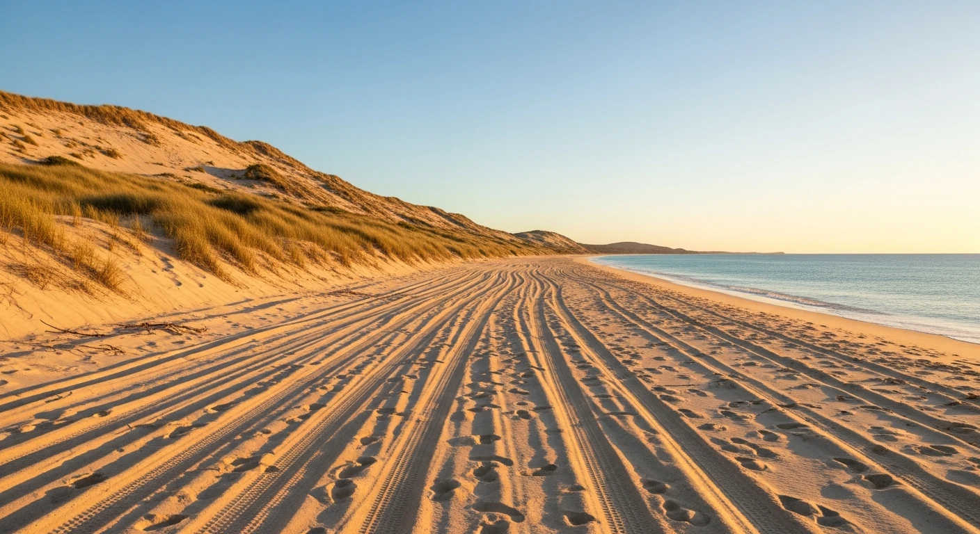
Beginner-friendly beach sand driving. The sand is firm at low tide and forgiving of minor mistakes. Soft patches near the dune line and at creek outlets are the only areas that catch people out. A good first beach 4WD trip for new drivers.
Scored 4.3/10 by Contour's road quality algorithm across curviness, surface, elevation and traffic. Best suited for 4wd drivers.
The road
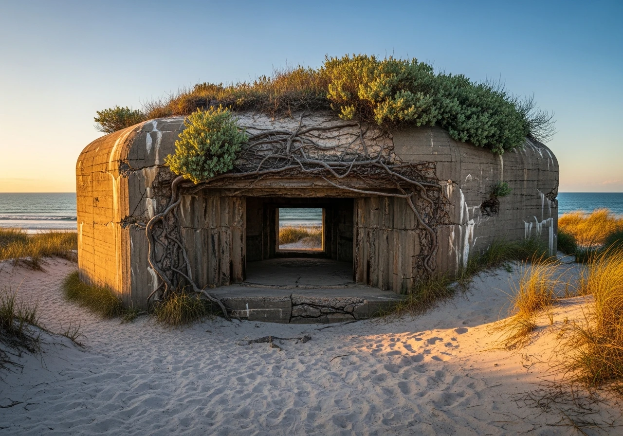
Bribie Island is the closest sand island to Brisbane and the easiest place to learn beach driving in southeast Queensland. The 23-kilometre run from the 4WD access point near Woorim Beach to the northern tip at Fort Bribie is simple, scenic and rewarding without being technical. The beach is wide and firm at low tide with a gentle slope. At high tide it narrows but remains driveable in most conditions. The drive passes through the ocean beach zone - pelicans, oystercatchers and the occasional dolphin pod visible offshore. The sand firms up significantly on the northern section near Fort Bribie. Fort Bribie at the end is a genuine reward - a network of concrete WWII fortifications built in 1941-42 to defend Moreton Bay from Japanese invasion. The bunkers, gun emplacements and observation posts are partially overgrown and largely unmarked, which makes exploring them more interesting than a formal heritage site. The pumicestone passage side of the island is visible from the fort area. The whole trip is manageable in 90 minutes with stops but most people stretch it to a half day with a swim and a wander through the fort ruins. Bribie is connected to the mainland by bridge so there is no barge cost - the only fees are the vehicle access permit from Moreton Bay Regional Council.
Bribie Island is the closest sand island to Brisbane and the easiest place to learn beach driving in southeast Queensland.
Why this road
The region
Bribie Island sits at the northern end of Moreton Bay, connected to the mainland by a bridge at Bellara. The southern end of the island is developed with residential suburbs and shops. The northern two-thirds is national park and undeveloped coast. The Pumicestone Passage between Bribie and the mainland is a shallow, protected waterway popular for kayaking and fishing. Caboolture on the mainland is 20 minutes away with all services.

Before you go
Fuel on the mainland at Caboolture or Bribie Island township before accessing the beach. Vehicle access permits required from Moreton Bay Regional Council - available online or from the visitor centre. Deflate tyres to 20-22 psi for the beach. Portable compressor needed for reinflation before returning to sealed roads. The beach is tide-dependent - check Moreton Bay tide tables and drive within two hours either side of low tide for the easiest run. High tide is manageable but the corridor narrows at several points. No mobile coverage at the northern end near Fort Bribie.
See a routing error?
Flag itWorth stopping for
Glass House Mountains
Volcanic plugs visible from the Bribie Island bridge - 30 minutes inland with walking tracks and lookouts.
Pumicestone Passage kayaking
The sheltered passage between Bribie and the mainland is excellent for a morning paddle with pelicans and ray sightings.
Route
Start
Woorim Beach
End
Fort Bribie
Gallery

More roads like this