Yerranderie Ghost Town
65 km
distance
3h 30m
Contour time
5.2
avg score
Unsealed
surface
Scenery
New South Wales
The Burragorang Valley is the drowned valley behind Warragamba Dam. Before the dam was completed in 1960, the valley...
Road quality
5.2 RQS
Every segment scored on 40+ data signals.
Accessibility
Fully sealed
Best in 4WD. Peak season: March-November.
7-day forecast
A long approach on deteriorating track that is not technically extreme but requires commitment. The final descent into the Burragorang Valley is steep and loose. Stock 4WDs handle it in dry conditions. The main challenge is the distance from help.
Scored 5.2/10 by Contour's road quality algorithm across curviness, surface, elevation and traffic. Best suited for 4wd drivers.
The road
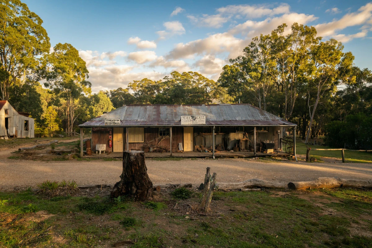
Yerranderie is a silver mining ghost town in the Burragorang Valley, south-west of Sydney. It sits just 100 kilometres from the Sydney CBD as the crow flies, but reaching it by road requires a 65-kilometre unsealed track from Oberon via Shooters Hill that takes over three hours. The town was established in 1893 when silver-lead deposits were found in the valley. At its peak it had a population of 2,000, two hotels, a school, a police station and a post office. The silver ran out by the 1920s and the town emptied. What remains is a handful of intact buildings, mine workings in the hillside and the cemetery on the ridge above the town. The track from Shooters Hill crosses the Great Dividing Range and descends through progressively wilder country. The upper sections are reasonable gravel road through pine plantation and native forest. Below the treeline the track deteriorates as it drops towards the Wollondilly River and the Burragorang Valley. The final descent is steep, loose and winding with limited visibility around the bends. The valley itself is striking - deep, enclosed and dramatically steep-sided, with the Wollondilly River running through the floor. Warragamba Dam, which supplies most of Sydney's drinking water, sits at the valley's eastern end. The dam's catchment restrictions have kept the valley undeveloped since the 1950s, which is why Yerranderie remains largely as it was left. The private trust that manages the town site allows camping and day visits. The old post office building serves as a basic shelter and information point. The isolation of the place is its primary quality - you are genuinely alone in a landscape that most people in Sydney have never heard of, let alone visited.
Yerranderie is a silver mining ghost town in the Burragorang Valley, south-west of Sydney.
Why this road
The region
The Burragorang Valley is the drowned valley behind Warragamba Dam. Before the dam was completed in 1960, the valley was farming and mining country with several small settlements. Most were abandoned when the dam was built and the water rose. Yerranderie survived because it sits above the dam's full supply level, but the road access from the east was flooded and the only remaining approach is the long track from the west via Oberon. Oberon itself is a small tablelands town at 1,100 metres elevation, known for timber and cold winters.

Before you go
Fuel at Oberon before departure - there is nothing between Oberon and Yerranderie. The track is best in dry conditions and can become very difficult after rain, particularly the descent into the valley. No phone coverage for the entire route. A PLB or satellite communicator is recommended. Camping at Yerranderie is managed by the Yerranderie Private Town trust - check availability before going. The return journey uses the same track, so allow a full day for the round trip. Water at Yerranderie is rainwater tank only - carry your own supply.
See a routing error?
Flag itWorth stopping for
Yerranderie cemetery
On the ridge above town with graves dating from the 1890s silver rush. The headstones tell the story of the town's brief prosperity.
Oberon
A cold-climate tablelands town with good pubs and the Jenolan Caves Road nearby - worth an overnight stop before or after the track.
Route
Start
Shooters Hill, Oberon
End
Yerranderie
Gallery

More roads like this
