Bridle Track
55 km
distance
3h
Contour time
8.1
avg score
Unsealed
surface
Scenery
New South Wales
The central tablelands between Bathurst and Mudgee are dry, open country at around 600-800 metres elevation. Bathurst...
Road quality
8.1 RQS
Strong. Above average on most quality signals.
Accessibility
Fully sealed
Best in 4WD. Peak season: March-November.
7-day forecast
A mix of gravel road and rougher track sections. The Monaghans Bluff diversion is the most committed section with steep descents and loose surfaces. Stock 4WDs handle the track in dry conditions without issue.
Scored 8.1/10 by Contour's road quality algorithm across curviness, surface, elevation and traffic. Best suited for 4wd drivers.
The road
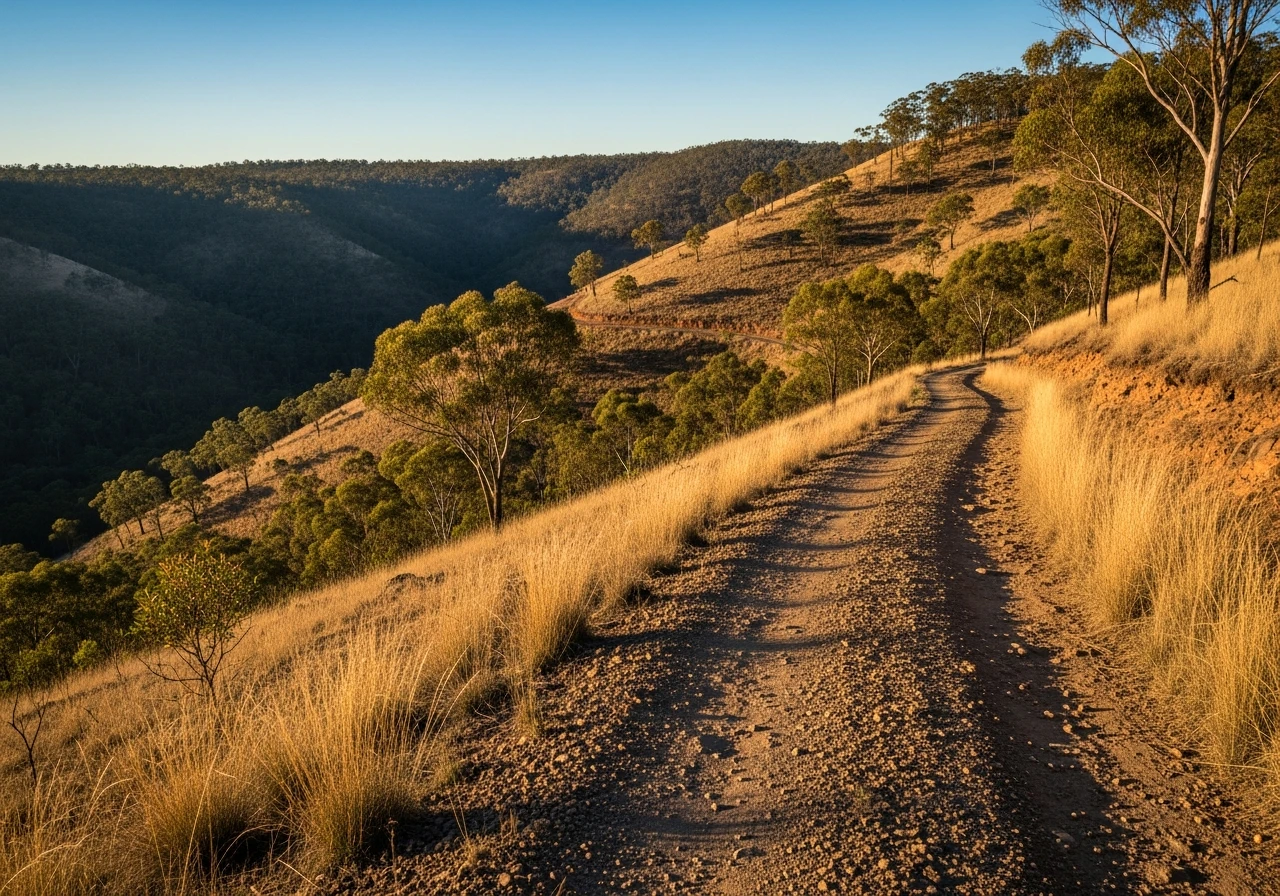
The Bridle Track is the original route that gold rush miners took from Bathurst to the Hill End goldfields in the 1850s. It runs 55 kilometres through the central tablelands of New South Wales, crossing dry creek beds, climbing timbered ridges and descending into the Turon River valley before ending at Hill End - a town that once had a population of 8,000 and now has roughly 100 permanent residents. The track follows the old bridle path that was the only overland connection to the goldfields before the road from Mudgee was built. Monaghans Bluff is the signature feature - a steep descent off the ridgeline with loose gravel and a sharp drop-off that requires careful line selection. The diversion around the bluff avoids the steepest section but adds distance and its own set of challenges on a narrow sidecut track. The country through here is quintessential central tablelands - dry sclerophyll woodland, ironbark and box, scattered granite outcrops and the Turon River cutting through the valley floor. Hill End itself is preserved as a historic site by NSW National Parks. The Royal Hotel is still operating - it opened in 1872 and the bar has not changed materially since. The town has a collection of intact gold rush era buildings, mine workings and the Bald Hill mine site where a 286-kilogram reef gold specimen - the Holtermann Nugget - was found in 1872. That single nugget made Hill End briefly one of the wealthiest settlements in the colony. The drive from Bathurst takes three hours with stops and the history layered into the landscape makes the track worth more than its technical challenge alone.
The Bridle Track is the original route that gold rush miners took from Bathurst to the Hill End goldfields in the 1850s.
Why this road
The region
The central tablelands between Bathurst and Mudgee are dry, open country at around 600-800 metres elevation. Bathurst is the oldest inland settlement in Australia, established in 1815. The goldfields north of Bathurst - Hill End, Sofala, Ophir - produced some of the largest gold finds in colonial history and the landscape still carries the evidence in the form of mine shafts, sluice races and abandoned settlements. The Turon River runs through the valley below the Bridle Track and was one of the first alluvial gold sites in the colony.

Before you go
Fuel at Bathurst. There is a small general store at Hill End but do not rely on it for fuel. The Bridle Track is best in dry conditions - the clay sections become difficult after rain and the Monaghans Bluff descent is not recommended when wet. Phone coverage is limited once you leave Bathurst. The Royal Hotel at Hill End serves meals and has basic accommodation. Camping is available at the Hill End Historic Site camping ground managed by NSW National Parks - bookings recommended on weekends.
See a routing error?
Flag itWorth stopping for
Hill End Historic Site
NSW National Parks manages the town as a living historic site. The Bald Hill mine, the main street buildings and the cemetery all reward a slow walk.
Sofala
Australia's oldest surviving gold town, 30 km south of Hill End on the Turon River. The pub and general store date from the 1850s.
Route
Start
Bathurst
End
Hill End
Gallery

More roads like this
