Watagans State Forest
60 km
distance
4h
Contour time
4.4
avg score
Unsealed
surface
Scenery
New South Wales
The Watagan Mountains form a low range between the Hunter Valley wine country to the west and the Central Coast to the...
Road quality
4.4 RQS
Every segment scored on 40+ data signals.
Accessibility
Fully sealed
Best in 4WD. Peak season: Year-round.
7-day forecast
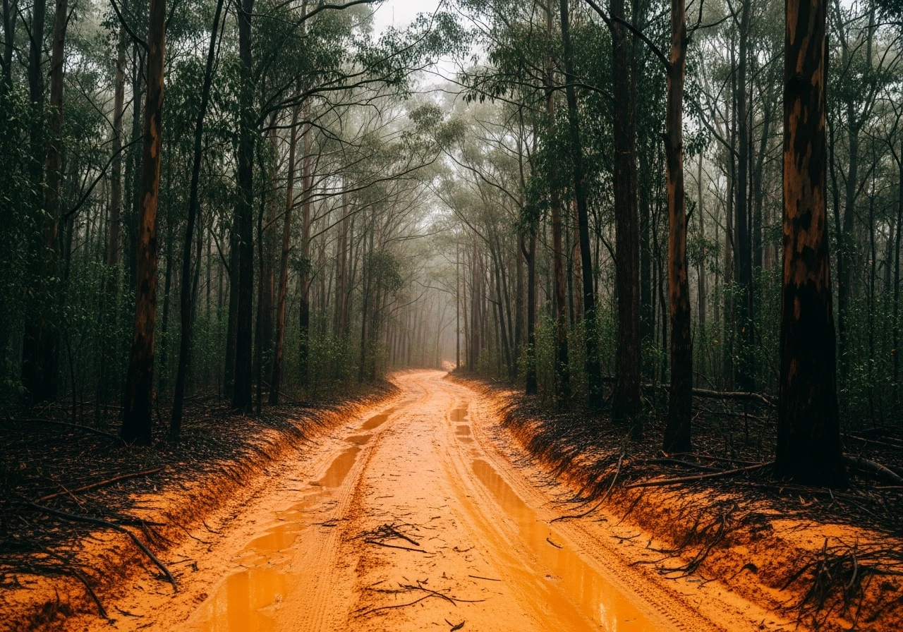
The network has tracks ranging from easy fire trails to the Daniels Point Road clay section which gets genuinely slippery when wet. Good for learning vehicle limits in a controlled environment. Multiple exit points reduce commitment.
Scored 4.4/10 by Contour's road quality algorithm across curviness, surface, elevation and traffic. Best suited for 4wd drivers.
The road
Watagans State Forest sits in the Watagan Mountains between the Hunter Valley and the Central Coast, roughly equidistant from Sydney and Newcastle. It has been the go-to training ground for new 4WD owners in the region for decades, and the network of tracks through the forest offers everything from easy graded fire trails to the notoriously slippery Daniels Point Road clay section that sorts out overconfident beginners. The forest covers about 7,000 hectares of dense eucalypt with deep gullies, sandstone ridgelines and a canopy that closes overhead on the narrower tracks. The 60-kilometre network connects a series of named tracks and fire trails that can be linked into half-day or full-day loops. Gap Creek Falls is the signature destination - a waterfall accessible via a steep descent that tests low-range technique on the way in and hill-climbing ability on the way out. The clay sections are the real character test. When dry, the clay is grippy and predictable. After rain it becomes a frictionless orange surface that defeats traction control systems and teaches the value of momentum and tyre placement. Daniels Point Road after heavy rain has produced more recovery stories than almost any other track within two hours of Sydney. The forest is well-managed by Forestry Corporation NSW and the tracks are maintained regularly, though the clay sections are deliberately left rough to provide the challenge that draws people here. Multiple entry and exit points mean you can bail out if conditions deteriorate without committing to a long return journey.
Watagans State Forest sits in the Watagan Mountains between the Hunter Valley and the Central Coast, roughly equidistant from Sydney and Newcastle.
Why this road
The region
The Watagan Mountains form a low range between the Hunter Valley wine country to the west and the Central Coast to the east. Cessnock is the nearest large town - the gateway to the Hunter Valley wineries and a practical base for a day in the forest. The forest itself is surrounded by farmland and sits at a modest 400-600 metres elevation. It is close enough to Sydney and Newcastle that day trips are standard.

Before you go
Fuel at Cessnock, Morisset or Wyong. The forest is open year-round but the clay tracks become very difficult after heavy rain - this is part of the appeal but carry recovery gear. Phone coverage is patchy throughout the forest. Multiple entry points from both the Hunter Valley and Central Coast sides mean you are never more than 30 minutes from sealed road. Gap Creek Falls descent is the most committed section - assess conditions at the top before going down. Camping is permitted at designated sites within the state forest.
See a routing error?
Flag itWorth stopping for
Hunter Valley wineries
Cessnock is the gateway town - a day in the Watagans pairs well with a Hunter Valley dinner afterwards.
Gap Creek Falls
The main waterfall within the forest, reached via a steep track descent that is one of the more technical sections in the network.
Route
Start
Watagan Creek Road
End
Cessnock side exit
Gallery

More roads like this
