Barrington Tops 4WD
135 km
distance
3h 30m
Contour time
5.3
avg score
Unsealed
surface
Scenery
New South Wales
Barrington Tops National Park and the surrounding state forests cover the plateau. The nearest towns are Gloucester to...
Road quality
5.3 RQS
Every segment scored on 40+ data signals.
Accessibility
Fully sealed
Best in 4WD. Peak season: October-April.
7-day forecast
The plateau tracks are accessible to most capable 4WDs in dry conditions. Wet conditions on the clay sections of the plateau approach make this significantly harder - the clay becomes slippery and the tracks bog easily. Best attempted in spring and autumn when conditions are typically dry.
Scored 5.3/10 by Contour's road quality algorithm across curviness, surface, elevation and traffic. Best suited for 4wd drivers.
The road
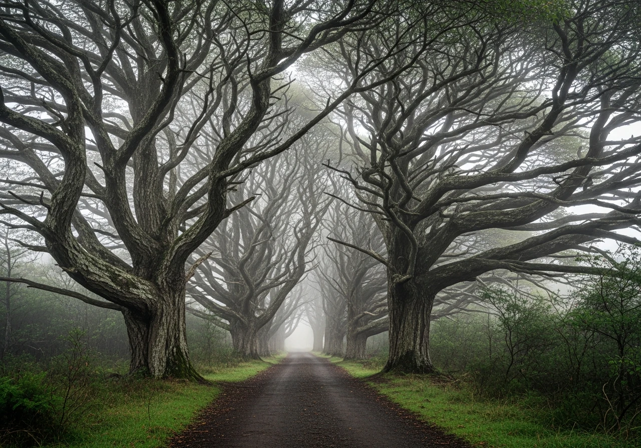
The Barrington Tops plateau sits at 1,500m on the Great Dividing Range, 250km north of Sydney. It is one of the few places on mainland Australia where Gondwana rainforest - the ancient Antarctic beech - survived the drying of the continent. The 4WD track from Gloucester crosses the escarpment and enters the plateau through stands of beech with bark like grey elephant hide and branches permanently bent by the prevailing westerly. In mist, the beech forest is the most evocative landscape in New South Wales. The plateau is flat grassland above the treeline, with the forest on the escarpment slopes and in the drainage gullies. The track connects to the sealed Barrington Tops Road on the western side, allowing a full traverse from the Hunter Valley to the Manning. The wild weather on the plateau is part of the experience - summer thunderstorms roll in from the coast with little warning and the temperature drops 15 degrees when they hit.
The Barrington Tops plateau sits at 1,500m on the Great Dividing Range, 250km north of Sydney.
Why this road
The region
Barrington Tops National Park and the surrounding state forests cover the plateau. The nearest towns are Gloucester to the east (Hunter Valley side) and Scone to the west. Both have fuel and accommodation. The plateau is World Heritage listed as part of the Gondwana Rainforests of Australia.

Before you go
Fuel in Gloucester and Scone. The plateau tracks can close after heavy rain - check NSW National Parks road conditions before departure. Weather on the plateau is unpredictable in all seasons - carry warm clothing regardless of the forecast. Phone coverage on the plateau is very limited. Camping is permitted at designated sites within the national park.
See a routing error?
Flag itWorth stopping for
Gloucester Tops picnic area
The start of the Gondwana walk - a short loop through the first beech forest stands, good for orienting before the drive.
Hunter Valley wineries
An hour south of Gloucester on the return - Australia's most established wine region makes a strong contrast to the wilderness plateau above it.
Route
Start
Gloucester
End
Scone (via Tops)
Gallery

More roads like this
