Blue Mountains Narrow Neck
10 km
distance
1h
Contour time
4.7
avg score
Unsealed
surface
Scenery
New South Wales
The Blue Mountains World Heritage Area covers this country. Katoomba is the main town on the plateau - an hour by train...
Road quality
4.7 RQS
Every segment scored on 40+ data signals.
Accessibility
Fully sealed
Best in 4WD. Peak season: Year-round.
7-day forecast
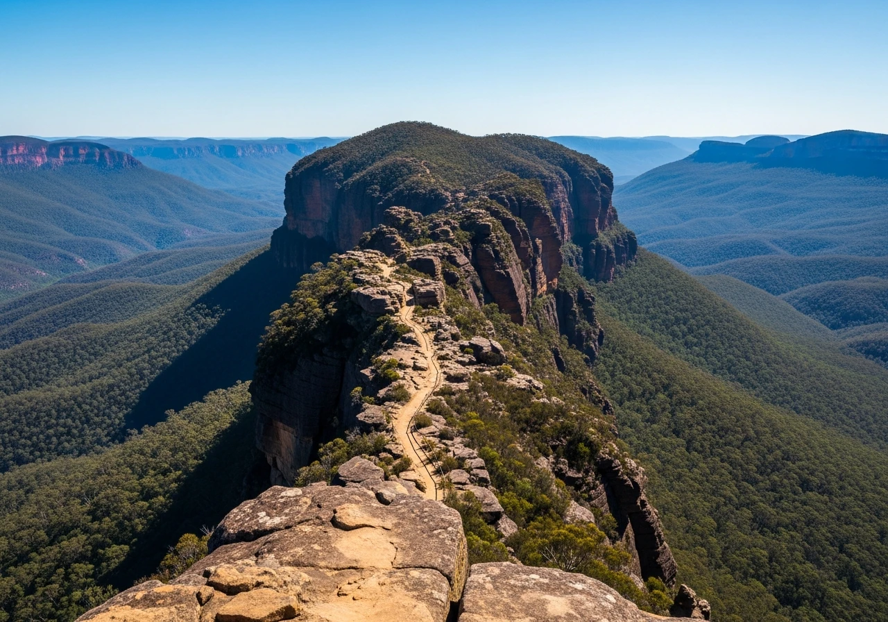
A rocky plateau ridge track that requires good clearance and low-range on the technical sections. The track narrows to single width on the crest of the neck with canyon walls visible either side. No room to turn around in sections - commit fully before entering.
Scored 4.7/10 by Contour's road quality algorithm across curviness, surface, elevation and traffic. Best suited for 4wd drivers.
The road
Narrow Neck is a sandstone ridge track in the Blue Mountains, 90 minutes from Sydney. It follows the peninsula of Narrow Neck Plateau south from Katoomba - a ridge that narrows in places to 50 metres wide with sheer sandstone cliffs dropping hundreds of metres to the Jamison Valley on the east and the Megalong Valley on the west. The track is rocky, technical in sections, and delivers some of the most spectacular canyon views accessible by 4WD anywhere near a major city. The Three Sisters are visible from the early part of the track. Mount Solitary sits in the middle of the Jamison Valley below - an isolated sandstone mesa with hiking tracks to the summit. The plateau surface is sandstone and loose rock on the upper sections and compacted dirt on the lower. In rain the track becomes slippery and the edge sections carry serious consequence. The track ends at Cedar Valley, where it is possible to return via the Megalong Valley on a mostly sealed route.
Narrow Neck is a sandstone ridge track in the Blue Mountains, 90 minutes from Sydney.
Why this road
The region
The Blue Mountains World Heritage Area covers this country. Katoomba is the main town on the plateau - an hour by train from Sydney with full services. The Megalong Valley below Narrow Neck is farming and horse country, a sharp contrast to the industrial-scale canyon visible from the ridge above.

Before you go
Fuel in Katoomba. Low-range required on the rocky crest sections. The track is narrow with no room to turn around - assess conditions before entering and do not proceed if you are not confident. Wet weather makes the sandstone sections slippery and the canyon edges dangerous. Do not attempt at night.
See a routing error?
Flag itWorth stopping for
Echo Point, Katoomba
The Three Sisters viewpoint - worth stopping before the track to orient yourself to the canyon system you are about to drive above.
Megalong Valley
The valley below Narrow Neck has an easy sealed return loop via Blackheath - a civilised exit after the track.
Route
Start
Narrow Neck gate
End
Clear Hill
Gallery

More roads like this
