Mt Terrible Track
59 km
distance
4h
Contour time
8.4
avg score
Unsealed
surface
1200m
max elevation
Scenery
1200m elevation
The Great Dividing Range between Eildon and Jamieson forms the backbone of the Victorian Alps. The country here is...
Road quality
8.4 RQS
Strong. Above average on most quality signals.
Accessibility
Fully sealed
Best in 4WD. Peak season: November-April.
7-day forecast
Stock 4WD with good clearance handles this in dry conditions. The track is long rather than technically hard - the main risk is distance from assistance. Modified vehicles find it comfortable but the length still demands respect.
Scored 8.4/10 by Contour's road quality algorithm across curviness, surface, elevation and traffic. Best suited for 4wd drivers.
The road
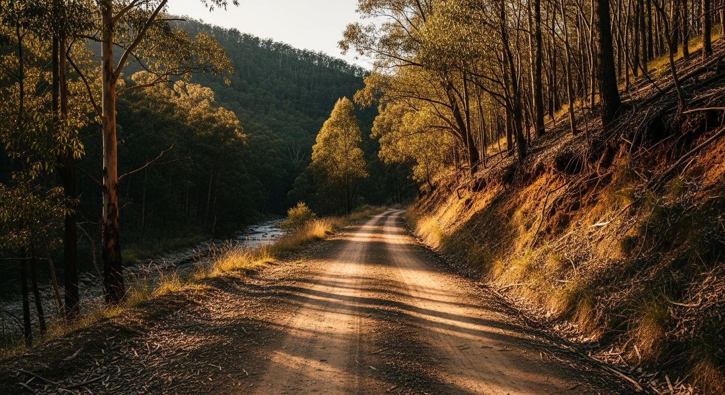
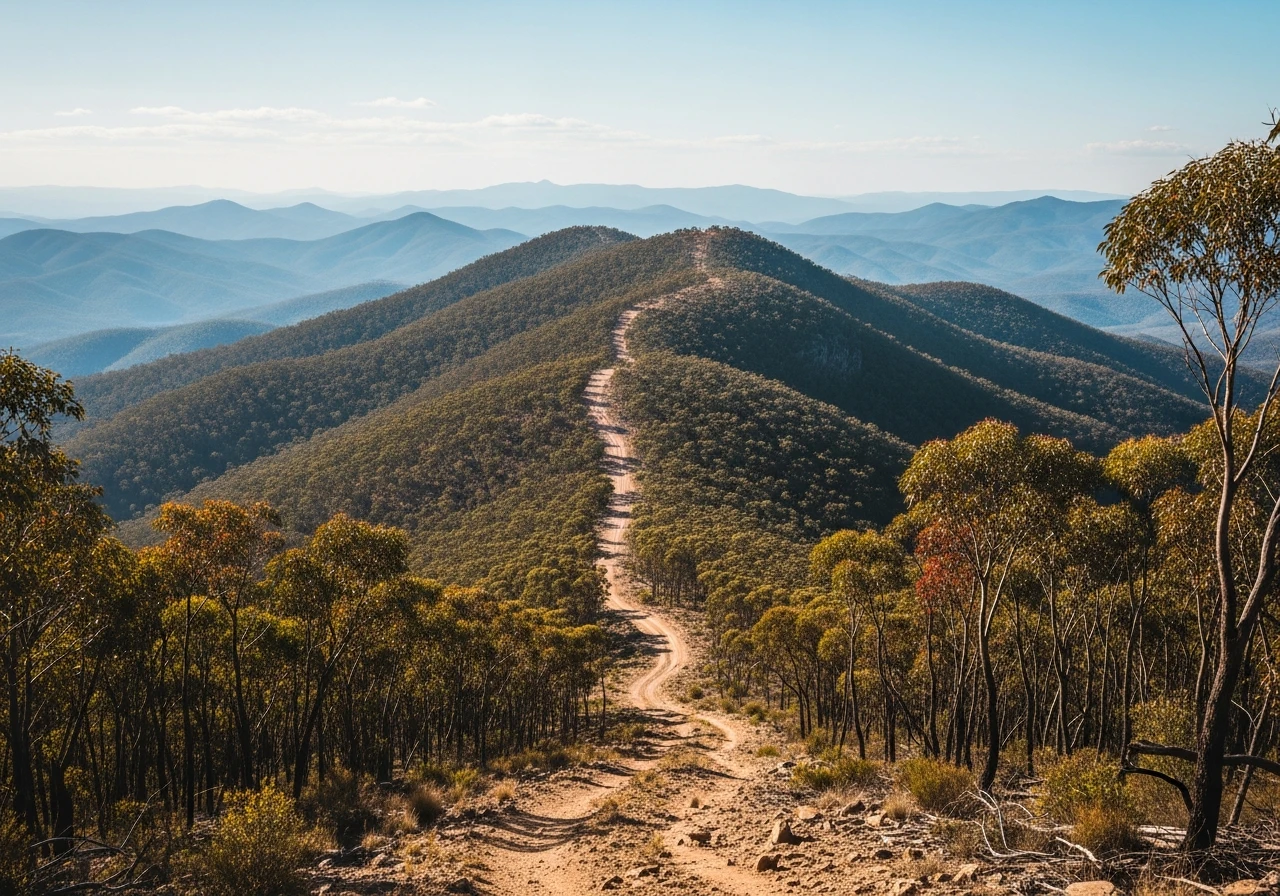
The Mt Terrible Track runs 59 kilometres along the spine of the Great Dividing Range between the Eildon-Jamieson Road and Ryan Spur Track near Kevington. The name refers to the mountain, not the track - though both earn respect. The track follows a ridgeline for much of its length, with views south over the Goulburn River catchment and north into the mountains beyond Jamieson. The signature section is Frenchmans Gap, where the track drops through a narrow saddle between ridges with steep forested slopes falling away on both sides. The gap is scenic rather than technically difficult, but it marks the transition between the western and eastern halves of the track. The surface varies between well-graded fire trail and rougher sections where water runoff has carved ruts into the clay. In dry conditions the whole track is accessible to a stock 4WD, but the length means any problem occurs a long way from help. The bush here is mixed eucalypt forest - stringybark and peppermint on the ridgetops, mountain ash in the gullies. The track passes several fire lookout points with cleared views, and the summit of Mt Terrible itself is accessible via a short spur. The mountain sits at roughly 1,200 metres and provides a broad panorama of the surrounding ranges. This is one of the longer ridgeline tracks in the Victorian Alps and the sense of isolation builds as the kilometres accumulate. Traffic is light even in peak season - it is possible to drive the entire track without seeing another vehicle.
The Mt Terrible Track runs 59 kilometres along the spine of the Great Dividing Range between the Eildon-Jamieson Road and Ryan Spur Track near Kevington.
Why this road
The region
The Great Dividing Range between Eildon and Jamieson forms the backbone of the Victorian Alps. The country here is high, forested and sparsely populated. Jamieson is a small town at the junction of the Jamieson and Goulburn rivers with a pub, a general store and a reputation as a gold rush settlement. Kevington at the eastern end is barely a settlement - a handful of houses on the Upper Goulburn. Lake Eildon is visible from several points on the western approach. The area was heavily affected by the 2006-07 bushfires and the regrowth forest is now well-established.

Before you go
Fuel at Eildon or Jamieson before entering. No services on the track. The 59-kilometre length means you are committed once you pass the halfway point - turning back adds distance. No mobile coverage for the full length. Carry a satellite communicator, extra water and basic recovery gear. The track is seasonal - closed by snow and mud from June to October. Allow a full day including stops.
See a routing error?
Flag itWorth stopping for
Jamieson Hotel
A classic country pub in a gold rush town. Good food and local knowledge about track conditions. Open daily.
Lake Eildon
Victoria's largest reservoir, visible from the western end of the track. Good fishing and boating in summer.
Route
Start
Eildon-Jamieson Road
End
Ryan Spur Track near Kevington
Gallery

More roads like this