Mitchell Plateau
245 km
distance
8h
Contour time
2.4
avg score
Unsealed
surface
Scenery
Western Australia
The Mitchell Plateau sits in the far north of the Kimberley region, one of the most sparsely populated areas in...
Road quality
2.4 RQS
Every segment scored on 40+ data signals.
Accessibility
Fully sealed
Best in 4WD. Peak season: May-September.
7-day forecast
Stock 4WD with good clearance and low-range. The track is rocky and rough in places with several river crossings that require commitment. Modified vehicles handle it more comfortably but the track is accessible to well-prepared stock 4WDs in the dry season.
Scored 2.4/10 by Contour's road quality algorithm across curviness, surface, elevation and traffic. Best suited for 4wd drivers.
The road
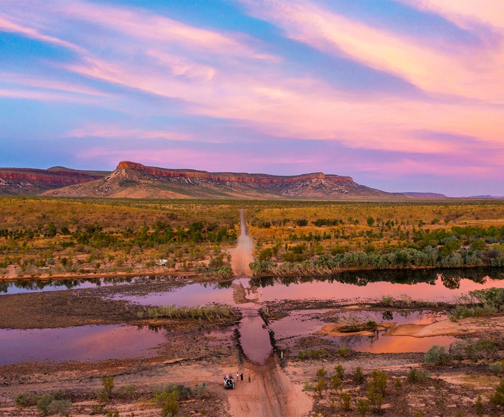
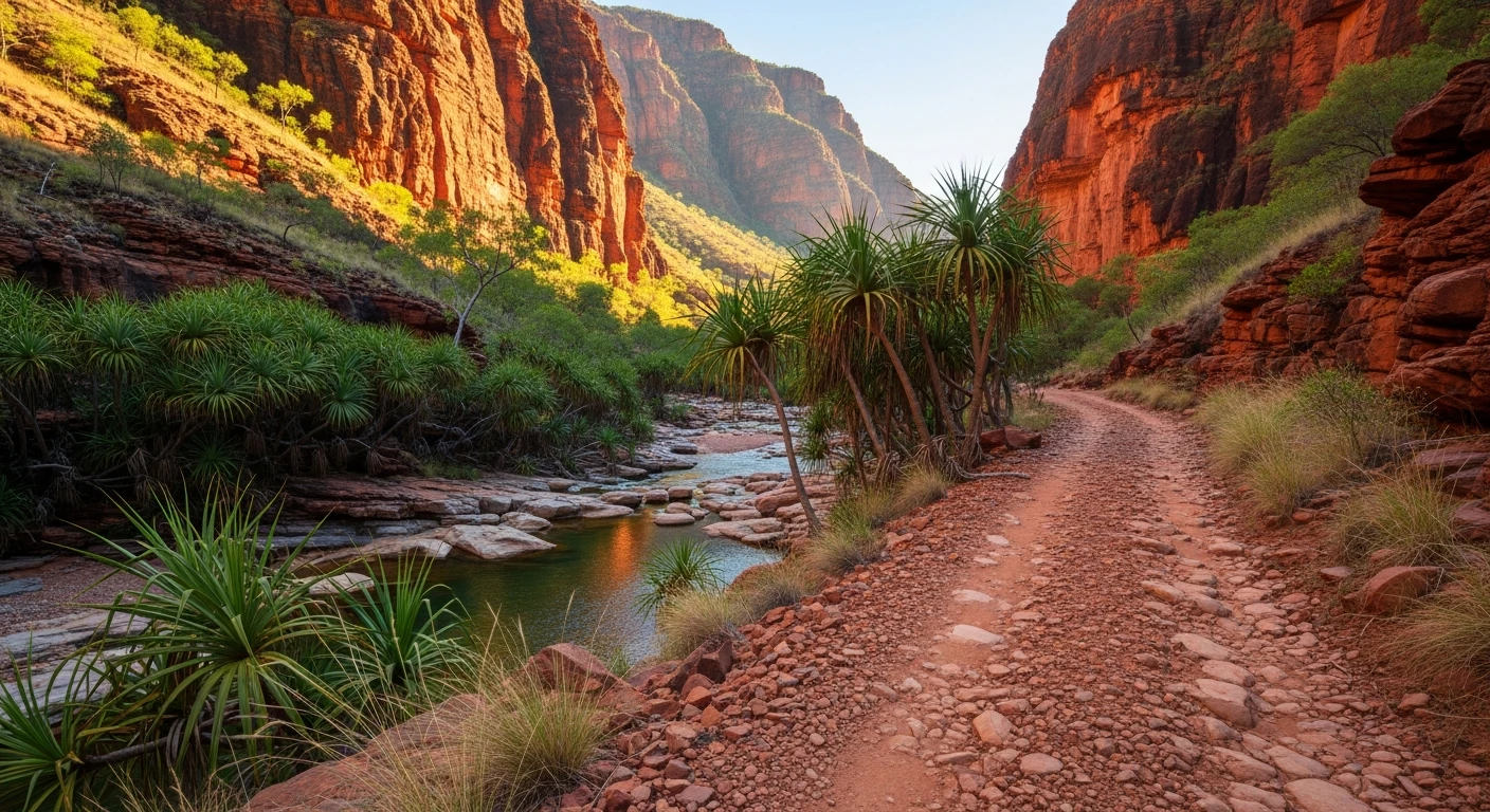
The Mitchell Plateau track runs 245 kilometres from the Kalumburu Road junction on the Gibb River Road to the Mitchell Falls campground in the far north Kimberley. This is the most remote major waterfall access in Australia and the track to reach it is a significant part of the experience. The road starts as a reasonable gravel track heading north from the Gibb, passing through savannah woodland with boab trees and termite mounds. The King Edward River crossing is the first major obstacle - a wide rocky river crossing that varies from shin-deep in the late dry season to impassable early in the season. Beyond the river the track becomes rougher, with rocky sections, deep ruts and creek crossings that test clearance and approach angles. The last 90 kilometres to the Mitchell Plateau are the most demanding - corrugated red dirt alternating with rock and sand. The Mitchell Falls themselves are reached via a 3.6-kilometre walk from the campground. The falls drop in four tiers over a sandstone escarpment into deep plunge pools surrounded by fan palms and monsoon vine thickets. Aboriginal rock art galleries are visible along the walking track, painted on the sandstone shelves above the falls. Scenic helicopter flights from the campground provide an aerial view of the falls and the surrounding plateau. The Mitchell Plateau is part of the Ngauwudu (Mitchell Plateau) Aboriginal Reserve, and an Uunguu Visitor Pass is required from the Wunambal Gaambera Aboriginal Corporation. The remoteness of the destination means that reaching the campground feels like a genuine achievement.
The Mitchell Plateau track runs 245 kilometres from the Kalumburu Road junction on the Gibb River Road to the Mitchell Falls campground in the far north Kimberley.
Why this road

The region
The Mitchell Plateau sits in the far north of the Kimberley region, one of the most sparsely populated areas in Australia. The plateau is a sandstone tableland dissected by rivers that flow north to the Timor Sea. The vegetation is tropical savannah on the plateau top and monsoon rainforest in the gorges. The nearest settlement is Kalumburu, an Aboriginal community 260 km to the northeast. The Gibb River Road is the lifeline for the entire northern Kimberley, and the Mitchell Plateau turnoff adds a significant detour to any Gibb trip.

Before you go
An Uunguu Visitor Pass is required from the Wunambal Gaambera Aboriginal Corporation - purchase online before your trip. No fuel on the track. Drysdale River Station is the last reliable fuel stop before the plateau - fill up there or at Mt Elizabeth before turning north. Carry extra fuel for at least 500 km and 20 litres of extra water. No mobile coverage. Satellite communicator essential. The track is only accessible in the dry season - May to September. The King Edward River crossing determines access - check conditions before committing. Helicopter flights over Mitchell Falls can be booked at the campground. Allow a full day to drive in and a day to walk to the falls.
See a routing error?
Flag itWorth stopping for
Drysdale River National Park
Remote national park between the Gibb River Road and the Mitchell Plateau. Limited access but extraordinary wilderness for those who get in.
Kalumburu community
The most northerly settlement in Western Australia. A small Aboriginal community with basic services and the starting point for Kimberley coast boat tours.
Route
Start
Kalumburu Road junction
End
Mitchell Falls campground
Gallery

More roads like this