Litchfield - Reynolds River and Lost City
30 km
distance
2h
Contour time
8.6
avg score
Unsealed
surface
Scenery
Northern Territory
Litchfield National Park is 100 kilometres south of Darwin via the Stuart and Litchfield Park roads. The park covers...
Road quality
8.6 RQS
Exceptional. Consistently high curviness, surface, and low traffic.
Accessibility
Fully sealed
Best in 4WD. Peak season: May-October.
7-day forecast
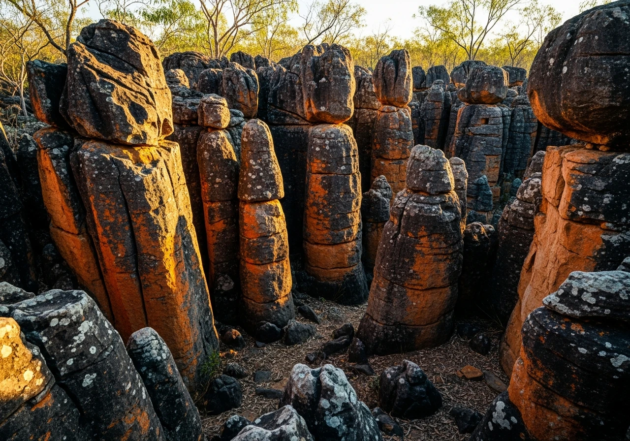
The Reynolds River crossing is the main technical feature - a wide rocky crossing that varies from ankle-deep in the early dry to knee-deep by October. The track to the Lost City is rough but not technical. Stock 4WDs handle this comfortably in the dry season.
Scored 8.6/10 by Contour's road quality algorithm across curviness, surface, elevation and traffic. Best suited for 4wd drivers.
The road
Litchfield National Park is the Top End's most accessible national park, and most visitors never leave the sealed roads that connect the major waterfalls. The 4WD sections in the park's south offer a different experience - a Reynolds River crossing and the Lost City sandstone formation that most day-trippers from Darwin never see. The Reynolds River crossing is a wide, shallow ford over a rocky river bed. In the early dry season (May-June) the water is ankle-deep and the crossing is straightforward. By late dry season (September-October) the water drops further and the rocks become more exposed. The crossing is impassable in the wet season when the river runs full and fast. Beyond the crossing the track follows a rough corridor through open woodland to the Lost City - a collection of weathered sandstone pillars and blocks that resemble ruined buildings. The pillars are formed by differential erosion of the Tolmer Sandstone, which is between 1.8 and 1.4 billion years old. The harder layers resist erosion while the softer layers crumble away, creating columns, arches and passageways through the rock. The Lost City is not large but it is atmospheric - the pillars are head-height to twice head-height, close together and covered in orange and black lichen that gives them an ancient, built quality. Walking through the formation you can see why it earned its name. The surrounding park is typical Top End woodland - stringybark eucalypt, spear grass and termite mounds. The magnetic termite mounds on the sealed section of the park are famous, but the cathedral mounds near the Lost City track are equally impressive and far less visited. The 4WD track adds genuine character to a Litchfield visit that would otherwise be a series of sealed-road waterfall car parks.
Litchfield National Park is the Top End's most accessible national park, and most visitors never leave the sealed roads that connect the major waterfalls.
Why this road
The region
Litchfield National Park is 100 kilometres south of Darwin via the Stuart and Litchfield Park roads. The park covers the Tabletop Range - a sandstone plateau with rivers cascading off the edges as waterfalls. Florence Falls, Wangi Falls and Buley Rockhole are the main sealed-road destinations. The 4WD tracks access the southern and western sections of the park where the landscape is less dramatic but quieter. Batchelor is the nearest town with fuel and basic services.

Before you go
Fuel at Batchelor or Darwin. The 4WD sections are open May to October only - the Reynolds River crossing floods in the wet season and the tracks become impassable. Check crossing conditions with NT Parks before departure as the river level varies through the dry season. The Lost City has no facilities - carry water and sunscreen. The 4WD section can be combined with the sealed-road waterfalls for a full day in Litchfield. Phone coverage is intermittent within the park.
See a routing error?
Flag itWorth stopping for
Florence Falls
The best swimming waterfall in Litchfield - a double cascade into a monsoon forest plunge pool. Sealed road access from the main park road.
Magnetic Termite Mounds
Flat blade-shaped termite mounds aligned north-south to regulate temperature. A short sealed-road stop on the way to the 4WD section.
Route
Start
Litchfield NP southern entry
End
Lost City
Gallery

More roads like this