Grand Pacific Drive
46 km
distance
1h 20m
Contour time
4.8
avg score
Sealed
surface
Scenery
New South Wales
The northern Illawarra coast is squeezed between the Illawarra Escarpment and the ocean - in places the strip of flat...
Road quality
4.8 RQS
Every segment scored on 40+ data signals.
Accessibility
Fully sealed
Best in Sports car. Peak season: Year-round.
7-day forecast
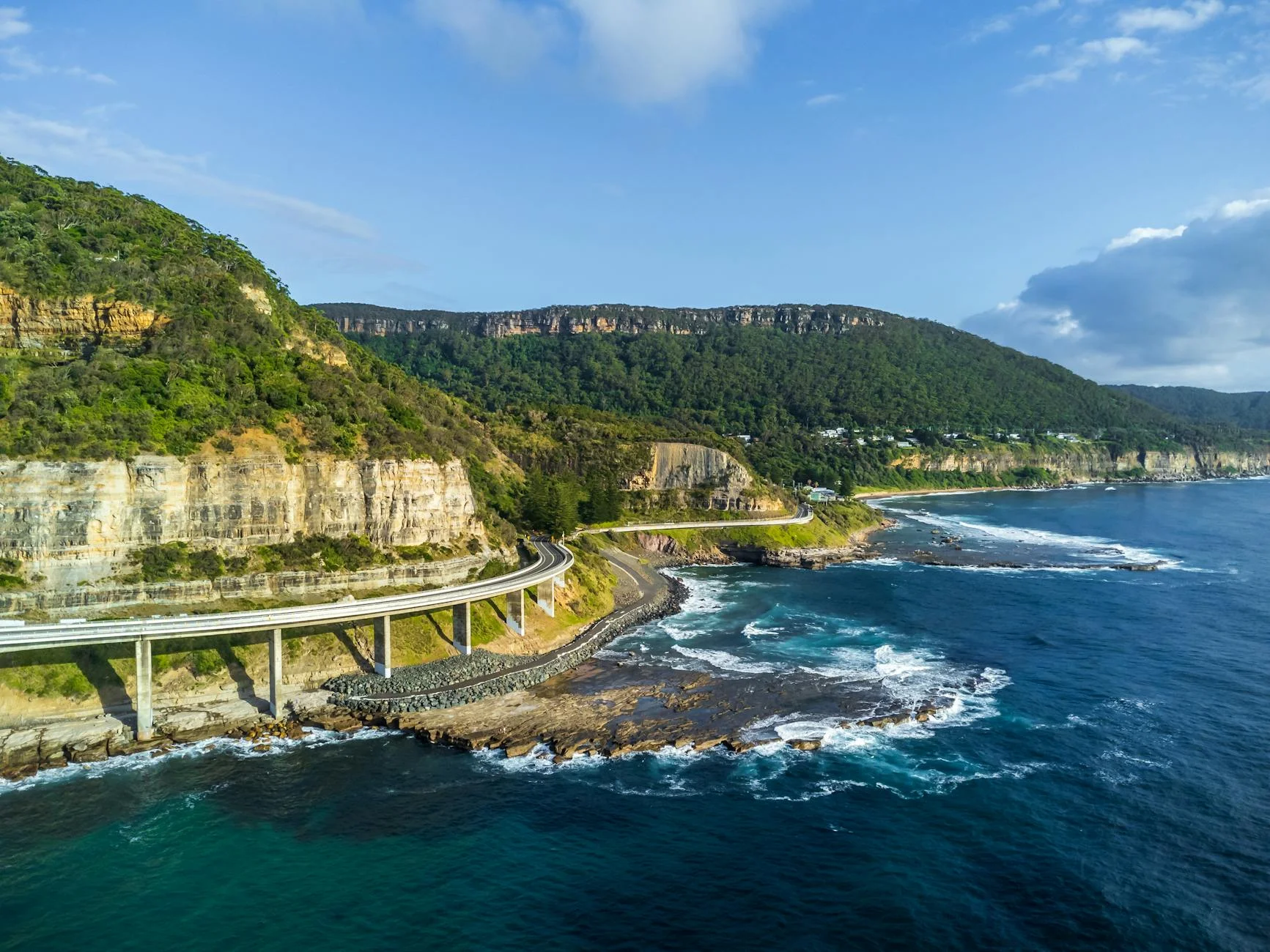
Smooth sealed coastal road with a mix of cliff-edge sections, rainforest curves and the 665-metre Sea Cliff Bridge cantilevered over the ocean. The pace is moderate rather than fast - the scenery is part of the point.
Scored 4.8/10 by Contour's road quality algorithm across curviness, surface, elevation and traffic. Best suited for sports car drivers.
The road
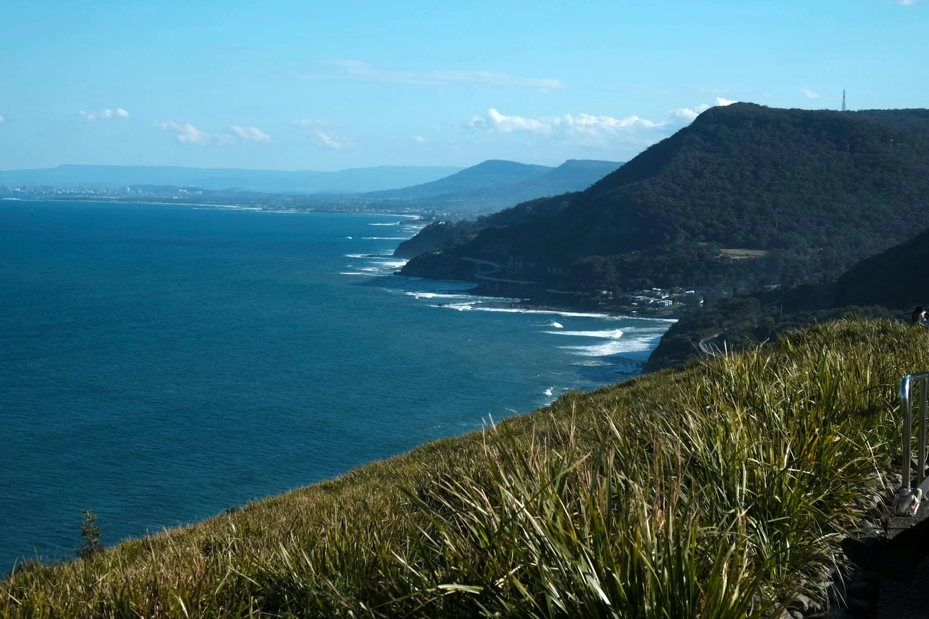
The Grand Pacific Drive is a 140-kilometre signed tourist route from the Royal National Park to the Shoalhaven, but the section that earns the reputation is the 36-kilometre northern stretch from Stanwell Tops to Wollongong. This is where the Illawarra Escarpment meets the Pacific Ocean and the road clings to the narrow strip between the two. The Sea Cliff Bridge is the centrepiece - a 665-metre concrete bridge cantilevered off the cliff face above the ocean, replacing a section of road that kept getting buried by rockfalls. It is one of the most photographed pieces of road infrastructure in Australia and it genuinely delivers. But the bridge is just one moment in a drive that holds attention throughout. From Stanwell Tops the road descends through coastal scrub past Bald Hill lookout - a famous hang-gliding launch point with views north to Sydney and south along the coast. Below Bald Hill the road enters Stanwell Park and runs through a series of coastal villages - Coalcliff, Scarborough, Wombarra, Coledale - where the houses sit between the escarpment wall and the sea. The road through these villages is narrow, winding and distinctly coastal in character. South of Thirroul the road opens onto the Wollongong coastal plain with the escarpment still looming to the west.
Why this road

The region
The northern Illawarra coast is squeezed between the Illawarra Escarpment and the ocean - in places the strip of flat land is barely 500 metres wide. This geography creates a string of small coastal villages that feel isolated from the suburban sprawl of Sydney despite being only 60 kilometres south. Stanwell Tops sits at the top of the escarpment with views along the entire coast. Wollongong at the southern end is a proper city - Australia's ninth largest - with good food, good beaches and an industrial heritage built on coal and steel that still shapes the place.
Before you go
Fuel in Stanwell Tops and Wollongong. The road is fully sealed and open year-round. Parking at the Sea Cliff Bridge is limited - there is a pullover bay on the southern side and a car park at Coalcliff at the northern end. Bald Hill lookout fills quickly on weekends. The Royal National Park entry fee applies if you are coming from the north through the park. Allow 80 minutes without stops, but plan for stops - this drive rewards them.
See a routing error?
Flag itWorth stopping for
Bald Hill Lookout, Stanwell Tops
One of the best coastal viewpoints near Sydney. Hang-gliders and paragliders launch from here most weekends - worth 20 minutes to watch.
Royal National Park
Australia's oldest national park, directly north of Stanwell Tops. The coastal walk from Bundeena to Otford passes through sandstone country above the ocean.
Nan Tien Temple, Wollongong
The largest Buddhist temple in the southern hemisphere, set against the escarpment south of Wollongong. Open to visitors daily.
Route
Start
Stanwell Tops
End
Wollongong
Gallery
More roads like this
